Inside the Map of 30 Immigrant Enclaves
A map titled “NEW YORK CITY IMMIGRANT ENCLAVES” lists 30 entries and does not include Little Italy. The map was published by New York City Tourism + Conventions, and the map itself cites the NYC Mayor’s Office of Immigrant Affairs as its data source. No source in this collection identifies the map’s designer.
The Mayor’s Office of Immigrant Affairs launched an Immigrant Enclave Illustration Series on April 17, 2023. In its end-of-tenure report covering through December 31, 2025, the office states that 23 illustrations were published. Comparing that report with this map shows five names that appear on the map but not in the report: Little Egypt, Little Odessa, Little Palestine, Little Poland and Little Senegal.
On July 10, 2026, amNewYork reported that the mayor’s team had updated the map. At the same press conference, the mayor said the map had been created by the prior administration in 2023 and that future changes would include adding Little Italy. As of August 20, no amended version had been located, and the known map file remained byte-for-byte unchanged from an archived copy captured before the July reporting.
Published . Source pages and files can change after that time.
The map
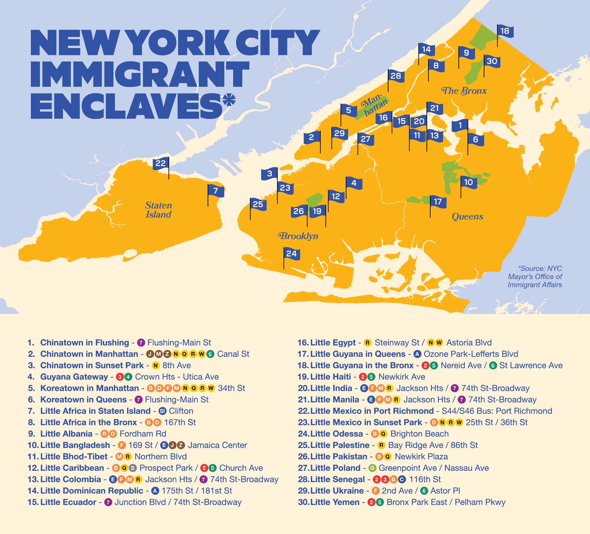
The map’s footnote reads “Source: NYC Mayor’s Office of Immigrant Affairs.” That identifies a data source; it does not name the map’s designer. The file carries no designer credit or authorship metadata.
The source image remains available at the publisher-served image address. The same bytes appear in an archived capture from June 17, 2026.
What the map lists
The table below transcribes the 30 entries and transit strings as printed on the map.
| # | Name as printed | Transit access as printed |
|---|---|---|
| 1 | Chinatown in Flushing | 7 Flushing-Main St |
| 2 | Chinatown in Manhattan | J M Z N Q R W 6 Canal St |
| 3 | Chinatown in Sunset Park | N 8th Ave |
| 4 | Guyana Gateway | 3 4 Crown Hts - Utica Ave |
| 5 | Koreatown in Manhattan | B D F M N Q R W 34th St |
| 6 | Koreatown in Queens | 7 Flushing-Main St |
| 7 | Little Africa in Staten Island | SI Clifton |
| 8 | Little Africa in the Bronx | B D 167th St |
| 9 | Little Albania | B D Fordham Rd |
| 10 | Little Bangladesh | F 169 St / E J Z Jamaica Center |
| 11 | Little Bhod-Tibet | M R Northern Blvd |
| 12 | Little Caribbean | B Q S Prospect Park / 2 5 Church Ave |
| 13 | Little Colombia | E F M R Jackson Hts / 7 74th St-Broadway |
| 14 | Little Dominican Republic | A 175th St / 181st St |
| 15 | Little Ecuador | 7 Junction Blvd / 74th St-Broadway |
| 16 | Little Egypt | R Steinway St / N W Astoria Blvd |
| 17 | Little Guyana in Queens | A Ozone Park-Lefferts Blvd |
| 18 | Little Guyana in the Bronx | 2 5 Nereid Ave / 6 St Lawrence Ave |
| 19 | Little Haiti | 2 5 Newkirk Ave |
| 20 | Little India | E F M R Jackson Hts / 7 74th St-Broadway |
| 21 | Little Manila | E F M R Jackson Hts / 7 74th St-Broadway |
| 22 | Little Mexico in Port Richmond | S44/S46 Bus: Port Richmond |
| 23 | Little Mexico in Sunset Park | D N R W 25th St / 36th St |
| 24 | Little Odessa | B Q Brighton Beach |
| 25 | Little Palestine | R Bay Ridge Ave / 86th St |
| 26 | Little Pakistan | B Q Newkirk Plaza |
| 27 | Little Poland | G Greenpoint Ave / Nassau Ave |
| 28 | Little Senegal | 2 3 B C 116th St |
| 29 | Little Ukraine | F 2nd Ave / 6 Astor Pl |
| 30 | Little Yemen | 2 5 Bronx Park East / Pelham Pkwy |
Little Italy is not among the 30 entries.
How the map compares with an earlier city series
The Mayor’s Office of Immigrant Affairs launched the Immigrant Enclave Illustration Series on April 17, 2023. In its end-of-tenure report covering through December 31, 2025, the office states that 23 illustrations were published. “Little Italy” does not appear in the 85-page report.
Five names appear on the map but nowhere in that report: Little Egypt, Little Odessa, Little Palestine, Little Poland and Little Senegal. The map therefore includes five names not found in the report.
Two reported criteria
Two source accounts describe different criteria for why a neighborhood might appear on the map. Neither appears in a published selection rule.
In a July 9, 2026 Washington Examiner article, a city spokesperson said the map highlights neighborhoods with substantial foreign-born populations. This describes a demographic criterion based on current population.
The Blaze quoted people who described a neighborhood’s history of immigrant settlement as a basis for inclusion. This describes a heritage criterion that does not depend on the current foreign-born share.
The two criteria ask different questions. A neighborhood can meet either, both or neither; the evidence does not establish that either criterion was the rule used to make the map.
A separate Department of City Planning threshold
The Department of City Planning’s The Newest New Yorkers 2026, Chapter 3 defines a “major immigrant neighborhood” for that report as one whose foreign-born density exceeds the city average, using a 40 percent threshold. It records SoHo-Little Italy at 30.5 percent.
The report scopes that definition to its own chapter. No source in this collection connects the threshold to the map, so the threshold is not treated here as an explanation for Little Italy’s absence.
What happened next
On July 10, 2026, amNewYork reported that the mayor’s team had updated the map. At the same press conference, the mayor said the map had been created by the prior administration in 2023 and said future changes would include adding Little Italy.
Checked on August 20, the known map file was unchanged from archived captures taken before the July reporting. The page that had carried the map redirected to the program index, while the image file was still served. No amended map was located.
What is not established
- Who designed the map.
- Whether a published or unpublished selection rule was used to choose the 30 entries.
- Why the original host-page URL now redirects.
- Whether an amended version adding Little Italy exists at another address; none was located in the sources checked.
Sources
- New York City Tourism + Conventions — map host page
- New York City Tourism + Conventions — source image
- Mayor's Office of Immigrant Affairs — impact report covering through December 31, 2025
- Department of City Planning — The Newest New Yorkers 2026, Chapter 3
- Washington Examiner — July 9, 2026 article reporting the demographic criterion
- The Blaze — article reporting the heritage criterion
- amNewYork — July 10, 2026 report of the mayor's statement
Rights
No open license was identified for the map, the city reports or the press reports cited on this page.
The map is reproduced here from a local copy verified against the governed checksum. No redistribution permission for the map was located or is claimed. New York City Tourism + Conventions is identified as the publisher; the original image address and an archived capture are linked above.
Validation
The structured representation contains eight claims corresponding to the eight governed records in this collection. Publication checks reconcile the roster in both directions, verify citations and governed confidence values, and reject missing required sections or unsupported private coordinates.
Limitations
This page describes this published map and the sources used to examine it. It is not a directory, ranking or definition of New York City’s immigrant neighborhoods.
No amended version of the map was located in the sources checked. That does not establish that an amended version does not exist at another address.
Publication history
- Sources retrieved and checksummed —
- Documents compared and the criteria examined —
- Amendment re-tested, still unobserved —
Broader NYC enclaves work
This article begins a broader KnoEdg.NYC effort to document NYC enclaves and communities across overlapping categories and time periods. The broader work will draw on multiple sources and will not treat this 30-entry map as a complete inventory or defining authority.
Technical depth
For provenance, confidence, validation and modeling details, read the technical data paper.